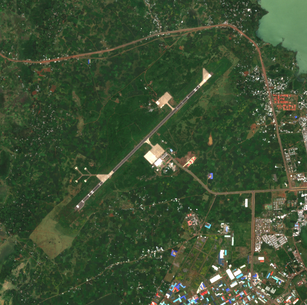
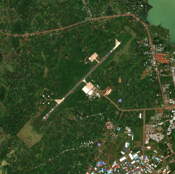
27 September, 08:06Z ·
before2 October, 08:06Z ·
after
6.1 km across · Sentinel-2 (S2B) MSI L2A ·
10.0 m per pixel · identical extent and scale
ይህ ሊያሳየው የሚችለው እና የማይችለው።
Sentinel-2 true colour at 10 m per pixel, acquired 83.1 h after the reported event time. One pixel is roughly the footprint of a small building, so damage to an individual structure, a crater, or munition debris would not be resolved. This imagery could show a burn scar, a large destroyed or removed structure, a plume caught at the moment of overpass, or substantial change to fuel or vehicle areas. Absence of visible change therefore carries little information about whether a small strike occurred. ACLED reports a suicide drone strike on an air force base. Destroyed aircraft on an apron, a burning fuel or ammunition store, or a large burn scar are all within reach of 10 m imagery; a single impact on a hardened structure is not.
ምርምር — ACLED expert comment, 'Blasts in Addis Ababa signal dangerous new phase in Ethiopia's conflict', attributed to Dr Jalale Getachew Birru, East Africa Senior Analyst. States that suicide drone strikes believed to have been carried out by the
በማህደር የተቀመጠ ቅጂ
የሙቀት — NASA FIRMS detections within 150 km of Belay Zeleke airport, 25 Sep - 2 Oct 2026: only four in the entire window, and NONE within 10 km of the airport at any time. The nearest ever was 54.7 km, on 29 September itself. Overpass coverage on 2
ከተመዘገበ ጥያቄ እንደገና የተፈጠረ
ጥልቅ ዳሰሳ
ምንጮች እና ቴክኒካዊ መነሻ
ACLED
ACLED expert comment, 'Blasts in Addis Ababa signal dangerous new phase in Ethiopia's conflict', attributed to Dr Jalale Getachew Birru, East Africa Senior Analyst. States that suicide drone strikes believed to have been carried out by the Alliance for Survival targeted, on the day following the Kombolcha strike, 'ENDF's air force base in Mekod area in Bahir Dar city in Amhara region'.
["earth-search STAC query (sentinel-2-l2a)", "windowed read of asset 'visual' at native resolution (EPSG:32637)", "bands 1-3 as RGB", "PNG encode"]
Bbox
[37.293688, 11.577031, 37.348712, 11.630929]
Crs
EPSG:4326
Resolution m
10.0
Cloud cover pct
2.7872
License
Copernicus Sentinel data 2026, processed by ESA. Free and open under the Copernicus licence; redistribution permitted with attribution.
Redistributable
True
Detectability note
Sentinel-2 true colour at 10 m per pixel, acquired 36.9 h before the reported event time. One pixel is roughly the footprint of a small building, so damage to an individual structure, a crater, or munition debris would not be resolved. This imagery could show a burn scar, a large destroyed or removed structure, a plume caught at the moment of overpass, or substantial change to fuel or vehicle areas. Absence of visible change therefore carries little information about whether a small strike occurred. ACLED reports a suicide drone strike on an air force base. Destroyed aircraft on an apron, a burning fuel or ammunition store, or a large burn scar are all within reach of 10 m imagery; a single impact on a hardened structure is not.
Satellite image · 2 Oct 2026
Sentinel-2 true-colour crop acquired 2026-10-02T08:06Z, after the reported strike. Footprint covers 100% of the requested area.
["earth-search STAC query (sentinel-2-l2a)", "windowed read of asset 'visual' at native resolution (EPSG:32637)", "bands 1-3 as RGB", "PNG encode"]
Bbox
[37.293688, 11.577031, 37.348712, 11.630929]
Crs
EPSG:4326
Resolution m
10.0
Cloud cover pct
0.108
License
Copernicus Sentinel data 2026, processed by ESA. Free and open under the Copernicus licence; redistribution permitted with attribution.
Redistributable
True
Detectability note
Sentinel-2 true colour at 10 m per pixel, acquired 83.1 h after the reported event time. One pixel is roughly the footprint of a small building, so damage to an individual structure, a crater, or munition debris would not be resolved. This imagery could show a burn scar, a large destroyed or removed structure, a plume caught at the moment of overpass, or substantial change to fuel or vehicle areas. Absence of visible change therefore carries little information about whether a small strike occurred. ACLED reports a suicide drone strike on an air force base. Destroyed aircraft on an apron, a burning fuel or ammunition store, or a large burn scar are all within reach of 10 m imagery; a single impact on a hardened structure is not.
Fire-detection data
NASA FIRMS detections within 150 km of Belay Zeleke airport, 25 Sep - 2 Oct 2026: only four in the entire window, and NONE within 10 km of the airport at any time. The nearest ever was 54.7 km, on 29 September itself. Overpass coverage on 29 September is strong, including night: VIIRS NOAA-20 at 00:03Z, 09:28Z, 11:06-11:08Z and 21:59-22:01Z, plus MODIS at 02:11Z, 06:22Z and 12:57Z, with that day's Ethiopian detections spanning latitudes 3.06-14.04.
Stream the open 7-day global CSVs for noaa-20-viirs-c2, suomi-npp-viirs-c2 and modis-c6.1 from firms.modaps.eosdis.nasa.gov/data/active_fire/, filter to Ethiopia then to within 150 km of the site. No API key needed. The window is ROLLING and was captured on 2026-10-02 covering 25 Sep - 2 Oct; after that date these files no longer reach this event, which is why the subset is stored here. For later work use the FIRMS archive API, which needs a free key.
Upstream sources
["NASA FIRMS / VIIRS and MODIS active fire products"]