Dahsas

በGoogle Translation የተተረጎመ · እንግሊዝኛ

3 ጥቅምት 2026 · አሉላ አባ ነጋ አየር ማረፊያ፣ መቀሌ

እውነት ነው?ሊሆን የሚችል~70%

ተዋጊዎች ሲያፈገፍጉ የመንግስት ኃይሎች የመቀሌ አየር ማረፊያን መቆጣጠራቸውን ምንጮች ዘግበዋል

ተሻሽሏል

የመንግስት ኃይሎች የመቀሌ አየር ማረፊያን መልሰው መቆጣጠራቸውን Reuters ዘግቧል፣ AFP ደግሞ የTPLF ተዋጊዎች እና መሪዎች ከተማዋን ለቀው እየወጡ መሆኑን ዘግቧል። ሁለቱም ስማቸው ባልተጠቀሰ ምንጮች ላይ ይመሰረታሉ። የአየር ማረፊያው ቁጥጥር የሙሉ መቀሌን ቁጥጥር አያረጋግጥም።

ትክክለኛውን የመያዣ ጊዜ፣ በከተማዋ ውስጥ ያለውን የቁጥጥር መጠን፣ ወይም ተቋማቱ ከተደራራቢ ምስክሮች ጋር መነጋገራቸውን አናውቅም። ዘገባዎቹ በ3 October የነበሩትን ሁኔታዎች ይገልጻሉ፤ እኛ የመሬት ላይ ሁኔታውን በተናጥል አላረጋገጥንም።

Claim
15204555809599 ← ተሰርዟል ተረጋግጧል →
በ3 October ዘገባ ጊዜ የመንግስት ኃይሎች የአሉላ አባ ነጋ አየር ማረፊያን ተቆጣጥረው ነበር።በReuters የተጠቀሱ ሶስት ስማቸው ያልተገለጸ ምንጮችሊሆን የሚችል
ሊሆን የሚችል
አንዳንድ የTPLF ተዋጊዎች እና መሪዎች በ3 October መቀሌን ለቀው እየወጡ ነበር።በAFP የተጠቀሱ አንድ የአካባቢ ጋዜጠኛ እና ነዋሪዎችሊሆን የሚችል
ሊሆን የሚችል

ሳተላይት

በፊት እና በኋላ

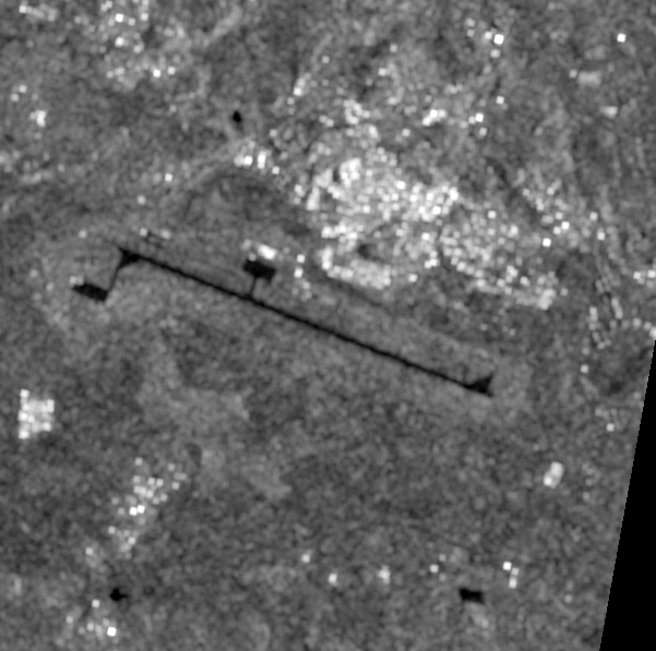
Satellite image before the reported event
21 September, 03:07Z · before
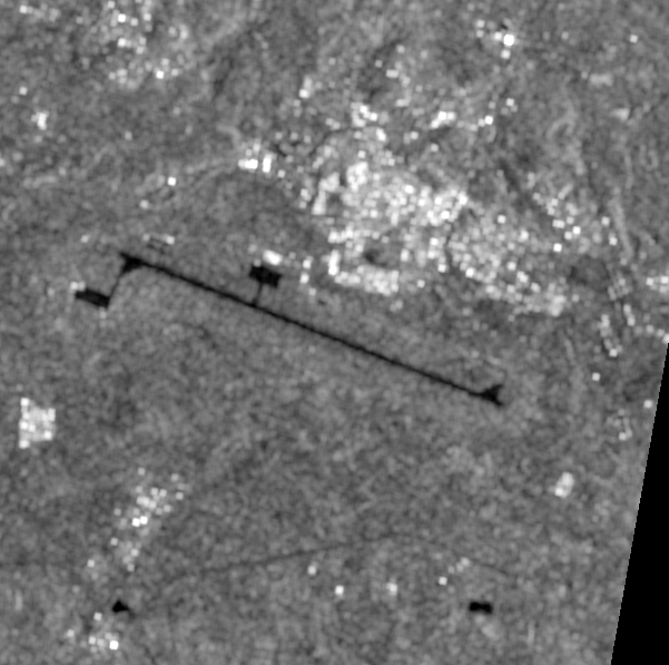
Satellite image after the reported event
3 October, 03:07Z · after

6.2 km across · Sentinel-1 (S1D) IW GRDH VV · 10.0 m per pixel · identical extent and scale

ይህ ሊያሳየው የሚችለው እና የማይችለው። Sentinel-1 VV ground-range amplitude at 10 m pixel spacing, about 20 m true resolution, from track 79 descending: 281.9 h before and 6.1 h after the reported time. Radar is unaffected by cloud, which is why it was used here. Amplitude responds to large, bright or geometric change: a destroyed building, new earthworks, vehicles or aircraft appearing or leaving a hardstanding, flooding. It is not interferometric coherence and is much less sensitive to structural damage, so absence of amplitude change is weak evidence that nothing happened. It carries no information at all about who holds a place.
ምልከታዎች

ማስረጃው የሚያሳየው

የምናየው

የአየር ማረፊያው የኦፕቲካል ሳተላይት ምስል እንደገና ተይዟል ከተባለው በፊት ይገኛል እንጂ ከዚያ በኋላ አይገኝም። የ 4 October ማለፊያ 56-60% ደመና ነው። ራዳር ክስተቱ ከተፈጠረ ከስድስት ሰዓታት በኋላ ተመሳሳይ ቦታን ሸፍኗል።

ከምን ጋር እንደሚጣጣም

የኦፕቲካል ማረጋገጫው ሊደረግ አልቻለም፣ እና ይህ ማረጋገጫው ባዶ ሆኖ ከመመለሱ የተለየ ነው። ኦክቶበር በትግራይ ከፍተኛ ቦታዎች ላይ የክረምት ወቅት ማብቂያ ነው፣ ስለዚህ ይህ ይደገማል፦ በዚህ ወቅት የዚህ ክልል የኦፕቲካል ምስል በማንኛውም የተሰጠ ቀን አስተማማኝ አይደለም። ይህ ያጋለጠው ክፍተት ከዚያን ጊዜ ጀምሮ ተዘግቷል — በወቅቱ ከላይ ያለፈው ራዳር አሁን ተቀነባብሯል፣ እና እዚህ እንደ s1-airfield-2026-10-03 ተመዝግቧል። በ 10 m፣ ኦፕቲካል በማንኛውም ሁኔታ በአውሮፕላን ማቆሚያው ላይ ትላልቅ ለውጦችን ወይም የቃጠሎ ጠባሳን ያሳይ ነበር እንጂ፣ በማኮብኮቢያው ወይም በአንድ ነጠላ መዋቅር ላይ የደረሰን ጉዳት አያሳይም ነበር።

የምናየው

ማኮብኮቢያው በሦስቱም ማለፊያዎች ላይ እንደ አንድ የተገናኘ low-backscatter ገጽታ ይነበባል። በ 9 September ማለፊያ ላይ ብቻ የተሰመረው አሻራው፣ በዘንጉ ላይ በ 22 degrees አቅጣጫ 3,706 m ይለካል፣ ይህ ደግሞ ከታተመው 02/20 ስያሜ ጋር ይዛመዳል። በዚያ ቋሚ ንድፍ ውስጥ በጣም ብሩህ የሆነው ፒክሰል በ 9 September -16.0 dB፣ በ 21 September -11.5 dB እና በ 3 October -11.5 dB ነው፤ በማንኛውም ማለፊያ ላይ ምንም ፒክሰል -10 dB አይደርስም። በውስጡ ያለው አማካይ backscatter በ 21 September እና በ 3 October መካከል በ 0.68 dB ይጨምራል፣ በተመሳሳይ የጊዜ ክፍተት ውስጥ ከታየው የ 1.14 dB ትዕይንት-አቀፍ መካከለኛ ጭማሪ አንፃር።

ከምን ጋር እንደሚጣጣም

ለስላሳ የተነጠፈ ወለል ራዳርን ከሴንሰሩ አርቆ ያንፀባርቃል እና ጨለማ ሆኖ ይነበባል። ጉድጓዶች፣ ፍርስራሾች፣ ትላልቅ ተሽከርካሪዎች ወይም በወለሉ ላይ የቆሙ አውሮፕላኖች በዚህ wavelength ብሩህ ናቸው እና በንድፉ ውስጥ ምላሾችን ከፍ ያደርጋሉ። አሃዞቹ በ 3 October ላይ ወደ 20 m ወይም ከዚያ በላይ በሆነ መጠን ምንም ዓይነት እንቅፋት ከሌለበት የማኮብኮቢያ ወለል ጋር ይጣጣማሉ፣ እና በንድፉ ውስጥ ያለው ጭማሪ በአጠቃላይ ትዕይንቱ ላይ ካለው ጭማሪ ያነሰ ነው። ይህ አየር ማረፊያውን ማን እንደተቆጣጠረው ምንም የሚለው ነገር የለም፣ እና ራዳር ይህን እንዲናገር ማድረግ አይቻልም።

የምናየው

በክስተቱ የጊዜ ክፍተት ውስጥ፣ ከ 6 km ሳጥን ውስጥ 1.2% ከ 3.7 dB በላይ ተለውጧል። በተመሳሳይ መስመር ላይ በሁለት ጸጥ ያሉ ቀናት መካከል ባለው ተመሳሳይ ርዝመት ባለው የመቆጣጠሪያ የጊዜ ክፍተት ውስጥ፣ አሃዙ 0.8% ነው። በመካከላቸው ያለው ልዩነት 0.3 የቦታ በመቶኛ ነጥቦች ነው።

ከምን ጋር እንደሚጣጣም

የክስተቱ የጊዜ ክፍተት በተመሳሳይ ቦታ ላይ ከተመሳሳይ ርዝመት ጸጥ ያለ የጊዜ ክፍተት የበለጠ ለውጥ አላመጣም። በዚህ resolution የራዳር amplitude ትልቅ፣ ብሩህ ወይም ጂኦሜትሪክ ለውጥን ይመዘግባል፤ እሱ interferometric coherence አይደለም እና ለመዋቅራዊ ጉዳት ያለው ስሜታዊነት በጣም ያነሰ ነው። እዚህ ላይ ባዶ ውጤት ምንም ነገር እንዳልተፈጠረ የሚያሳይ ደካማ ማስረጃ ነው፣ እና ስለ ቁጥጥር ምንም ዓይነት ማስረጃ አይደለም።

ግምገማዎች

የይገባኛል ጥያቄ በይገባኛል ጥያቄ

በ3 October ዘገባ ጊዜ የመንግስት ኃይሎች የአሉላ አባ ነጋ አየር ማረፊያን ተቆጣጥረው ነበር።

Claimed by በReuters የተጠቀሱ ሶስት ስማቸው ያልተገለጸ ምንጮች · source rating B2

ሊሆን የሚችል 55–80%

Reuters የሶስት ምንጮችን ዘገባዎች ይጠቅሳል። ያ ይህንን ዘገባ ይደግፋል፣ ነገር ግን Reuters የነሱን አባባሎች በተናጥል ማረጋገጥ አልቻለም።

ደጋፊ ማስረጃ

Reuters via The Star

ጉዳዩን የሚያወሳስበው

የአንድን ከተማ መቆጣጠር ማለት እያንዳንዱን የከተማዋን ክፍል ከመቆጣጠር ጋር አንድ አይደለም፣ እና በርካታ ምንጮች ስማቸው ያልተጠቀሰ ነው። ደመና የኦፕቲካል ሳተላይት ፍተሻውን ስለከለከለው፣ በውስጡ የሚያየውን ራዳር ተጠቅመናል፡ አየር ማረፊያው እንደገና ተይዟል ከተባለ ከስድስት ሰዓታት በኋላ ምስል ተነስቷል። ማኮብኮቢያው ነፃ ነው እና ከመደበኛ ልዩነት ውጭ ምንም የተቀየረ ነገር የለም — ነገር ግን ራዳር አንድን ቦታ ማን እንደተቆጣጠረው ሊያሳይ አይችልም፣ ስለዚህ ከዚህ ውስጥ አንዳቸውም በዚህ የተለየ የይገባኛል ጥያቄ ላይ ያለንን እምነት ከፍ አያደርጉም።

ሐሳባችንን ምን ሊለውጠው ይችላል

ቀን የተጻፈበት፣ መልክዓ-ምድራዊ አቀማመጡ የተረጋገጠ የአየር ማረፊያ ቁጥጥር ማስረጃ፣ በተናጥል የተቀመጡ ምስክሮች፣ ወይም ለዘገባው የሚደረግ እርማት ይህንን ግምገማ ሊለውጠው ይችላል።

አንዳንድ የTPLF ተዋጊዎች እና መሪዎች በ3 October መቀሌን ለቀው እየወጡ ነበር።

Claimed by በAFP የተጠቀሱ አንድ የአካባቢ ጋዜጠኛ እና ነዋሪዎች · source rating B2

ሊሆን የሚችል 55–80%

AFP ከከተማዋ ውስጥ ያሉ ዘገባዎችን ያስተላልፋል። እነሱ መውጣቶችን ይደግፋሉ፣ እንጂ እያንዳንዱ ተዋጊ ወጥቷል የሚለውን የይገባኛል ጥያቄ አይደለም።

ደጋፊ ማስረጃ

AFP via Dawn

ጉዳዩን የሚያወሳስበው

በዚያን ጊዜ ጋዜጠኛው የፌደራል ኃይሎችን በከተማው ውስጥ አላየም ነበር። እነዚህ ዘገባዎች ከሮይተርስ ምስክሮች ጋር መደራረባቸውን ማረጋገጥ አንችልም።

ሐሳባችንን ምን ሊለውጠው ይችላል

የመውጣቱን መጠን እና ጊዜ የሚያሳዩ፣ ወይም የተዘገበውን መውጣት የሚቃረኑ የተረጋገጡ ተንቀሳቃሽ ምስሎች ወይም ከገለልተኛ ምንጭ የተገኙ ዘገባዎች ይህንን ግምገማ ይቀይሩታል።

ምንጮች

ይህ የተመሰረተበት ሁሉም ነገር

  • ሪፖርት — Reuters report, updated 3 October, citing three unnamed sources on airport control and retaining its independent-verification caveat. በማህደር ያልተቀመጠ
  • ሪፖርት — AFP report of 3 October based on a local journalist and residents describing departures from Mekelle. Airport and citywide control are separate questions. በማህደር ያልተቀመጠ
  • ሳተላይት — Negative availability result for Alula Aba Nega Airport. A Sentinel-2 before/after comparison was attempted over a 3 km box centred on the airfield. A clean pre-event scene exists — 1 October 07:56Z, 13.7% cloud, 37 hours before the reporte ከተመዘገበ ጥያቄ እንደገና የተፈጠረ

ጥልቅ ዳሰሳ

ምንጮች እና ቴክኒካዊ መነሻ

Reuters via The Star

Reuters report, updated 3 October, citing three unnamed sources on airport control and retaining its independent-verification caveat.

Technical provenance
Timestamp basis
unknown
SHA-256
07eeb08ee0f53b02ebd9c2f66833d263c52b078e5646ca5a8fbc13cecdad3e12
Upstream sources
["Reuters"]

AFP via Dawn

AFP report of 3 October based on a local journalist and residents describing departures from Mekelle. Airport and citywide control are separate questions.

Technical provenance
Timestamp basis
unknown
SHA-256
664892afa5b3c5881829ba178e0e9f33d87de5497a4fab33bbc14b0d901b8810
Upstream sources
["AFP"]

Satellite catalogue query

Negative availability result for Alula Aba Nega Airport. A Sentinel-2 before/after comparison was attempted over a 3 km box centred on the airfield. A clean pre-event scene exists — 1 October 07:56Z, 13.7% cloud, 37 hours before the reported recapture — but no usable post-event scene does: the only pass after the event, 4 October 07:56Z, carries 56-60% cloud across both covering tiles. No pair was rendered, because half a comparison is not a comparison.

Technical provenance
Timestamp basis
unknown
Reproduction procedure
factcheck imagery mekelle-airport-withdrawals-2026-10-03 --days-before 20 --days-after 6 --max-cloud 25
Upstream sources
["Element 84 Earth Search v1 / AWS Open Data sentinel-cogs"]

Satellite image · 21 Sep 2026

Sentinel-1 VV radar backscatter over Alula Aba Nega Airport, 21 September 03:07Z — the last pass on this ground track before the reported recapture, and the 'before' half of the comparison.

Technical provenance
Captured at
2026-09-21 03:07:46+00:00
Timestamp basis
platform
Licence
Copernicus Sentinel data 2026, processed by ESA. Free and open under the Copernicus licence; redistribution permitted with attribution.
Reproduction procedure
factcheck sar mekelle-airport-withdrawals-2026-10-03
Upstream sources
["Element 84 Earth Search v1 / AWS Open Data sentinel-s1-l1c"]
Artifact type
sar_amplitude
Sensor
Sentinel-1 (S1D) IW GRDH VV
Acquisition start
2026-09-21T03:07:46.278728Z
Source scene id
S1D_IW_GRDH_1SDV_20260921T030733_20260921T030758_004670_008B9B
Source url
https://earth-search.aws.element84.com/v1/collections/sentinel-1-grd/items/S1D_IW_GRDH_1SDV_20260921T030733_20260921T030758_004670_008B9B
Source catalog
Element 84 Earth Search v1 / AWS Open Data sentinel-s1-l1c
Artifact path
media/artifacts/81a97e5aa44c9e62.png
Sha256
81a97e5aa44c9e6297a512a0eb86cd0c10be9b54bdbe11ac8d1822715441cd7e
Processing
["earth-search STAC query (sentinel-1-grd)", "windowed read of VV (713x717 px)", "DN to sigma-nought via the product calibration LUT", "5x5 boxcar in linear power (speckle)", "geocoded via 15 geolocation grid points to EPSG:32637 at 10 m"]
Bbox
[39.505689, 13.440451, 39.561111, 13.494349]
Crs
EPSG:32637
Resolution m
10.0
License
Copernicus Sentinel data 2026, processed by ESA. Free and open under the Copernicus licence; redistribution permitted with attribution.
Redistributable
True
Detectability note
Sentinel-1 VV ground-range amplitude at 10 m pixel spacing, about 20 m true resolution, from track 79 descending: 281.9 h before and 6.1 h after the reported time. Radar is unaffected by cloud, which is why it was used here. Amplitude responds to large, bright or geometric change: a destroyed building, new earthworks, vehicles or aircraft appearing or leaving a hardstanding, flooding. It is not interferometric coherence and is much less sensitive to structural damage, so absence of amplitude change is weak evidence that nothing happened. It carries no information at all about who holds a place.

Satellite image · 3 Oct 2026

Sentinel-1 VV radar backscatter over Alula Aba Nega Airport, 3 October 03:07Z — 6.1 hours after the reported recapture. Radar is unaffected by the cloud that made the optical check impossible (s2-no-usable-after).

Technical provenance
Captured at
2026-10-03 03:07:46+00:00
Timestamp basis
platform
Licence
Copernicus Sentinel data 2026, processed by ESA. Free and open under the Copernicus licence; redistribution permitted with attribution.
Reproduction procedure
factcheck sar mekelle-airport-withdrawals-2026-10-03
Upstream sources
["Element 84 Earth Search v1 / AWS Open Data sentinel-s1-l1c"]
Artifact type
sar_amplitude
Sensor
Sentinel-1 (S1D) IW GRDH VV
Acquisition start
2026-10-03T03:07:46.313322Z
Source scene id
S1D_IW_GRDH_1SDV_20261003T030733_20261003T030758_004845_0091B4
Source url
https://earth-search.aws.element84.com/v1/collections/sentinel-1-grd/items/S1D_IW_GRDH_1SDV_20261003T030733_20261003T030758_004845_0091B4
Source catalog
Element 84 Earth Search v1 / AWS Open Data sentinel-s1-l1c
Artifact path
media/artifacts/6fd2569c056affa8.png
Sha256
6fd2569c056affa801f7398469c2979523f3c6952974788ae470170005c91240
Processing
["earth-search STAC query (sentinel-1-grd)", "windowed read of VV (713x717 px)", "DN to sigma-nought via the product calibration LUT", "5x5 boxcar in linear power (speckle)", "geocoded via 15 geolocation grid points to EPSG:32637 at 10 m"]
Bbox
[39.505689, 13.440451, 39.561111, 13.494349]
Crs
EPSG:32637
Resolution m
10.0
License
Copernicus Sentinel data 2026, processed by ESA. Free and open under the Copernicus licence; redistribution permitted with attribution.
Redistributable
True
Detectability note
Sentinel-1 VV ground-range amplitude at 10 m pixel spacing, about 20 m true resolution, from track 79 descending: 281.9 h before and 6.1 h after the reported time. Radar is unaffected by cloud, which is why it was used here. Amplitude responds to large, bright or geometric change: a destroyed building, new earthworks, vehicles or aircraft appearing or leaving a hardstanding, flooding. It is not interferometric coherence and is much less sensitive to structural damage, so absence of amplitude change is weak evidence that nothing happened. It carries no information at all about who holds a place.