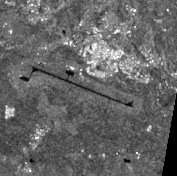
21 September, 03:07Z ·
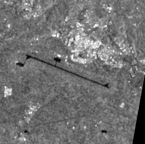
before3 October, 03:07Z ·
after
6.2 km across · Sentinel-1 (S1D) IW GRDH VV ·
10.0 m per pixel · identical extent and scale
እዚ ከርእዮ ዝኽእልን ዘይክእልን።
Sentinel-1 VV ground-range amplitude at 10 m pixel spacing, about 20 m true resolution, from track 79 descending: 281.9 h before and 6.1 h after the reported time. Radar is unaffected by cloud, which is why it was used here. Amplitude responds to large, bright or geometric change: a destroyed building, new earthworks, vehicles or aircraft appearing or leaving a hardstanding, flooding. It is not interferometric coherence and is much less sensitive to structural damage, so absence of amplitude change is weak evidence that nothing happened. It carries no information at all about who holds a place.
ጸብጻብ — Reuters report, updated 3 October, citing three unnamed sources on airport control and retaining its independent-verification caveat.
ዘይተዓቀበ
ጸብጻብ — AFP report of 3 October based on a local journalist and residents describing departures from Mekelle. Airport and citywide control are separate questions.
ዘይተዓቀበ
ሳተላይት — Negative availability result for Alula Aba Nega Airport. A Sentinel-2 before/after comparison was attempted over a 3 km box centred on the airfield. A clean pre-event scene exists — 1 October 07:56Z, 13.7% cloud, 37 hours before the reporte
ካብ ዝተመዝገበ ሕቶ ዳግማይ ዝተፈጠረ
ዓሚቝ ዳህሳስ
ምንጭታትን ቴክኒካዊ መበቆልን
Reuters via The Star
Reuters report, updated 3 October, citing three unnamed sources on airport control and retaining its independent-verification caveat.
AFP report of 3 October based on a local journalist and residents describing departures from Mekelle. Airport and citywide control are separate questions.
Negative availability result for Alula Aba Nega Airport. A Sentinel-2 before/after comparison was attempted over a 3 km box centred on the airfield. A clean pre-event scene exists — 1 October 07:56Z, 13.7% cloud, 37 hours before the reported recapture — but no usable post-event scene does: the only pass after the event, 4 October 07:56Z, carries 56-60% cloud across both covering tiles. No pair was rendered, because half a comparison is not a comparison.
["Element 84 Earth Search v1 / AWS Open Data sentinel-cogs"]
Satellite image · 21 Sep 2026
Sentinel-1 VV radar backscatter over Alula Aba Nega Airport, 21 September 03:07Z — the last pass on this ground track before the reported recapture, and the 'before' half of the comparison.
Technical provenance
Captured at
2026-09-21 03:07:46+00:00
Timestamp basis
platform
Licence
Copernicus Sentinel data 2026, processed by ESA. Free and open under the Copernicus licence; redistribution permitted with attribution.
Reproduction procedure
factcheck sar mekelle-airport-withdrawals-2026-10-03
Upstream sources
["Element 84 Earth Search v1 / AWS Open Data sentinel-s1-l1c"]
["earth-search STAC query (sentinel-1-grd)", "windowed read of VV (713x717 px)", "DN to sigma-nought via the product calibration LUT", "5x5 boxcar in linear power (speckle)", "geocoded via 15 geolocation grid points to EPSG:32637 at 10 m"]
Bbox
[39.505689, 13.440451, 39.561111, 13.494349]
Crs
EPSG:32637
Resolution m
10.0
License
Copernicus Sentinel data 2026, processed by ESA. Free and open under the Copernicus licence; redistribution permitted with attribution.
Redistributable
True
Detectability note
Sentinel-1 VV ground-range amplitude at 10 m pixel spacing, about 20 m true resolution, from track 79 descending: 281.9 h before and 6.1 h after the reported time. Radar is unaffected by cloud, which is why it was used here. Amplitude responds to large, bright or geometric change: a destroyed building, new earthworks, vehicles or aircraft appearing or leaving a hardstanding, flooding. It is not interferometric coherence and is much less sensitive to structural damage, so absence of amplitude change is weak evidence that nothing happened. It carries no information at all about who holds a place.
Satellite image · 3 Oct 2026
Sentinel-1 VV radar backscatter over Alula Aba Nega Airport, 3 October 03:07Z — 6.1 hours after the reported recapture. Radar is unaffected by the cloud that made the optical check impossible (s2-no-usable-after).
Technical provenance
Captured at
2026-10-03 03:07:46+00:00
Timestamp basis
platform
Licence
Copernicus Sentinel data 2026, processed by ESA. Free and open under the Copernicus licence; redistribution permitted with attribution.
Reproduction procedure
factcheck sar mekelle-airport-withdrawals-2026-10-03
Upstream sources
["Element 84 Earth Search v1 / AWS Open Data sentinel-s1-l1c"]
["earth-search STAC query (sentinel-1-grd)", "windowed read of VV (713x717 px)", "DN to sigma-nought via the product calibration LUT", "5x5 boxcar in linear power (speckle)", "geocoded via 15 geolocation grid points to EPSG:32637 at 10 m"]
Bbox
[39.505689, 13.440451, 39.561111, 13.494349]
Crs
EPSG:32637
Resolution m
10.0
License
Copernicus Sentinel data 2026, processed by ESA. Free and open under the Copernicus licence; redistribution permitted with attribution.
Redistributable
True
Detectability note
Sentinel-1 VV ground-range amplitude at 10 m pixel spacing, about 20 m true resolution, from track 79 descending: 281.9 h before and 6.1 h after the reported time. Radar is unaffected by cloud, which is why it was used here. Amplitude responds to large, bright or geometric change: a destroyed building, new earthworks, vehicles or aircraft appearing or leaving a hardstanding, flooding. It is not interferometric coherence and is much less sensitive to structural damage, so absence of amplitude change is weak evidence that nothing happened. It carries no information at all about who holds a place.