Dahsas

በGoogle Translation የተተረጎመ · እንግሊዝኛ

28 መስከረም 2026 · የኮምቦልቻ አየር ማረፊያ (DSE/HADC) እና አጎራባች የኢንዱስትሪ ፓርክ፣ አማራ

እውነት ነው?ዝቀተኛ አድል ያለው~35%

በኮምቦልቻ አየር ማረፊያ የነዳጅ ማከማቻ ላይ የተዘገበ የድሮን ጥቃት

ተሻሽሏል

ACLED በ28 September በኮምቦልቻ አየር ማረፊያ በሚገኝ የነዳጅ ማከማቻ ላይ የድሮን ጥቃት መፈጸሙን ዘግቧል፣ ይህንም ለAlliance for Survival ሰጥቶታል።

እኛ አጣርተናል። ከበፊት እና ከበኋላ የተነሱ የሳተላይት ምስሎች በአየር ማረፊያው ወይም በአጠገቡ ባለው የኢንዱስትሪ ፓርክ ምንም የተቃጠለ ጠባሳ አያሳዩም፣ እና የNASA እሳት-ፍለጋ መረጃ በ54km ክልል ውስጥ ምንም ሙቀት አልመዘገበም — የሳተላይት ማለፊያ አካባቢውን በሸፈነበት ቀን። ትልቅ የነዳጅ እሳት እርግጠኛት አልተከሰተም። ጥቃት ተሞክሮ ስቶ እንደሆነ፣ ወይም እንዳልተሳካ፣ እኛ ልንመልሰው የማንችለው የተለየ ጥያቄ ነው።

Claim
15204555809599 ← ተሰርዟል ተረጋግጧል →
በ28 September በኮምቦልቻ አየር ማረፊያ በሚገኝ የነዳጅ ማከማቻ ላይ የአጥፍቶ ጠፊ ድሮን ጥቃት ኢላማ አድርጓል።ACLED (ዶ/ር ጃላሌ ጌታቸው ብሩ፣ የምስራቅ አፍሪካ ከፍተኛ ተንታኝ)እኩል አድል ያለው
እኩል አድል ያለው
በ28 September ወይም በዚያ አካባቢ በኮምቦልቻ አየር ማረፊያ ትልቅ የነዳጅ እሳት ተከስቷል።የተዘገበውን ጥቃት ሴንሰሮች ሊለዩት ከሚችሉት ጋር ለመሞከር፣ የራሳችን አቀራረብዝቀተኛ አድል ያለው
ዝቀተኛ አድል ያለው

ሳተላይት

በፊት እና በኋላ

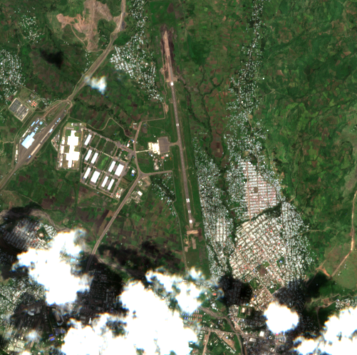
Satellite image before the reported event
24 September, 07:56Z · before
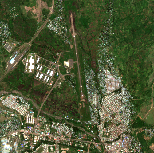
Satellite image after the reported event
29 September, 07:56Z · after

5.1 km across · Sentinel-2 (S2B) MSI L2A · 10.0 m per pixel · identical extent and scale

ይህ ሊያሳየው የሚችለው እና የማይችለው። Sentinel-2 true colour at 10 m per pixel, acquired 34.9 h after the reported event time. One pixel is roughly the footprint of a small building, so damage to an individual structure, a crater, or munition debris would not be resolved. This imagery could show a burn scar, a large destroyed or removed structure, a plume caught at the moment of overpass, or substantial change to fuel or vehicle areas. Absence of visible change therefore carries little information about whether a small strike occurred. For THIS incident the floor matters less than usual: the reported target is a fuel depot, and a burning fuel installation produces a soot and burn scar tens of metres across that persists for weeks. That is well within what 10 m imagery resolves. A null result here therefore carries real weight, unlike a null against a single munition impact.

ምልከታዎች

ማስረጃው የሚያሳየው

የምናየው

ተመሳሳይ የ 5.0 x 5.0 km ስፋት ያላቸውን የ 24 September እና 29 September ምስሎችን በማነጻጸር፣ እና በአውሮፕላን ማረፊያው ዙሪያ ያለውን ማዕከላዊ 1.8 km በመመርመር፣ ማኮብኮቢያው፣ የመንገደኛ መንገዱ፣ ኤፕሮኑ፣ የተርሚናል ሕንፃዎች እና በምዕራብ በኩል ያለው የኢንዱስትሪ ፓርክ ሁሉም ያልተነኩ እና ያልተለወጡ ሆነው ይታያሉ። ምንም የቃጠሎ ጠባሳ፣ ምንም የጠቆረ መሬት፣ ምንም የጥቀርሻ እድፍ፣ ምንም የፈረሰ ወይም የተወገደ መዋቅር እና ምንም የተረበሸ አፈር አይታይም። በሁለቱም ምስሎች ላይ ምንም የነዳጅ ማከማቻ መለየት አይቻልም፣ እና በ OpenStreetMap ውስጥ ምንም ካርታ አልተሰራም። በሁለቱ ቀናት መካከል ያሉት ልዩነቶች በመስክ ቀለም እና በአጠቃላይ ብሩህነት ላይ ብቻ የተገደቡ ናቸው። የ 24 September ትዕይንት በንጣፉ ላይ 19.7% ደመና ይዟል፣ ነገር ግን ደመናው በደቡብ-ምዕራብ ጥግ ላይ ይገኛል እና የአውሮፕላን ማረፊያው እና የኢንዱስትሪ ፓርኩ በሁለቱም ምስሎች ላይ ግልጽ ናቸው።

ከምን ጋር እንደሚጣጣም

በሁለቱ ቀናት መካከል በአውሮፕላን ማረፊያው ወይም በአቅራቢያው ባለው የኢንዱስትሪ ፓርክ ምንም ትልቅ እሳት ወይም መዋቅራዊ ውድመት ካለመኖሩ ጋር ይጣጣማል። በቦታው ላይ ድሮን መተኮሱን፣ መሳሪያ አርፎ ሳይቀጣጠል መቅረቱን፣ ወይም ትንሽ እሳት መሬቱን ከማጥቆሩ በፊት መቆጣጠር መቻሉን አይመልስም። የተዘገበው የነዳጅ ማከማቻ ቦታ ራሱ ያልተረጋገጠ ነው፣ ስለዚህ ይህ ምልከታ ከተረጋገጠ ኢላማ ይልቅ የተዘገበውን አካባቢ ይሸፍናል።

የምናየው

በ 28 September ወይም ከ 25 September እስከ 2 October ባለው ጊዜ ውስጥ በኮምቦልቻ አየር ማረፊያ ወይም በአቅራቢያው ምንም የ FIRMS የሙቀት ልየታ አልተከሰተም፤ በጣም ቅርብ የነበረው በ 25 September 54.4 km ርቀት ላይ ነበር። በ 28 September በ 11:25 UTC የ VIIRS NOAA-20 የቀን ቅኝት 120 km ርቀት ላይ 4.12 እና 2.56 MW የሙቀት ኃይል ያላቸው ሁለት እሳቶችን ለይቷል። በ 150 km አቅራቢያ የተገኙት ሁሉም ዘጠኝ ልየታዎች ከ 1.06 እስከ 30.94 MW ይደርሳሉ፣ ይህም የተለመደ የእርሻ ማቃጠል መጠን ነው።

ከምን ጋር እንደሚጣጣም

ከአዲስ ጉዳይ በተለየ፣ ይህ ባዶነት ትርጉም አልባ ከመሆን ይልቅ መረጃ ሰጪ ነው። የሚቃጠል የነዳጅ ማከማቻ ቀጣይነት ያለው፣ ከፍተኛ ኃይል ያለው የሙቀት ምንጭ ነው — እዚህ ከሚታየው 1-31 MW ዳራ በብዙ እጥፍ የሚበልጥ — እና በትክክል 375 m ሴንሰር እንዲለየው የተሰራው ነው። የ 28 September ቅኝት ሴንሰሩ በዚያ ቀን ይህን ኬክሮስ እየተመለከተ እንደነበር ተረጋግጧል፣ ስለዚህ አለመኖሩ የእሳት አለመኖር እንጂ ያለመመልከት አለመኖር አይደለም። ገደቦቹ እውነተኛ ናቸው ነገር ግን ከተለመደው የጠበቡ ናቸው፡ ሪፖርት የተደረገው ጥቃት ጊዜ አይታወቅም፣ የሳተላይት ቅኝቱ ቀጣይነት ያለው ክትትል ሳይሆን ቅጽበታዊ እይታ ነው፣ እና ከ 14:25 EAT በኋላ የተነሳ እና በፍጥነት የጠፋ እሳት በቅኝቶች መካከል ሊወድቅ ይችላል። አሁንም የተቃጠለ ጠባሳ ይተዋል ተብሎ ይጠበቃል፣ እና ምንም የሚታይ ነገር የለም።

ግምገማዎች

የይገባኛል ጥያቄ በይገባኛል ጥያቄ

በ28 September በኮምቦልቻ አየር ማረፊያ በሚገኝ የነዳጅ ማከማቻ ላይ የአጥፍቶ ጠፊ ድሮን ጥቃት ኢላማ አድርጓል።

Claimed by ACLED (ዶ/ር ጃላሌ ጌታቸው ብሩ፣ የምስራቅ አፍሪካ ከፍተኛ ተንታኝ) · source rating B3

እኩል አድል ያለው 45–55%

አንድ ምንጭ ይህንን ዘግቧል፣ እና ሁለተኛ አላገኘንም። ACLED ጥቃቱን ለAlliance for Survival የሚሰጠው እንደ እምነት እንጂ እንደ ግኝት አይደለም፣ እና ጥቃት መሞከሩን የምናረጋግጥበት ምንም መንገድ የለንም።

ጉዳዩን የሚያወሳስበው

No independent check run.

ሐሳባችንን ምን ሊለውጠው ይችላል

ማንኛውም መልክዓ-ምድራዊ አቀማመጡ የተረጋገጠ ምስል ወይም ቪዲዮ፣ በጥያቄ ውስጥ ባለው ምሽት የFIRMS የሙቀት ልየታ፣ ወይም የአየር ማረፊያ NOTAM። ዘገባዎቹ ወደ አንድ የማህበራዊ ሚዲያ ልጥፍ እንደሚመለሱ ማረጋገጥ ዝቅ ያደርገዋል።

በ28 September ወይም በዚያ አካባቢ በኮምቦልቻ አየር ማረፊያ ትልቅ የነዳጅ እሳት ተከስቷል።

Claimed by የተዘገበውን ጥቃት ሴንሰሮች ሊለዩት ከሚችሉት ጋር ለመሞከር፣ የራሳችን አቀራረብ · source rating F6

ዝቀተኛ አድል ያለው 20–45%

ይህ ያለን በጣም ግልጽ የሆነ መልስ ነው። የሚቃጠል የነዳጅ ማከማቻ የሳተላይት ምስሎችም ሆኑ የእሳት-ፍለጋ ሴንሰሮች ሊያዩት የሚችሉት ያህል ትልቅ እና ሞቃት ነው፣ እና በዚያ ቀን የሳተላይት ማለፊያ አካባቢውን ሸፍኗል። ሁለቱም ምንም አላዩም፣ እና ከአምስት ቀናት በኋላ ምንም የተቃጠለ ጠባሳ አይታይም። የማከማቻው ትክክለኛ ቦታ ስላልተረጋገጠ እና ቶሎ የጠፋ ትንሽ እሳት ከሁለቱም ፍተሻዎች ሊያመልጥ ስለሚችል ሙሉ በሙሉ ተሰርዟል ከማለት እንቆጠባለን።

ጉዳዩን የሚያወሳስበው

This is the first null result in this ledger that carries real weight, and the reason is specific: the claimed effect is matched to what the instruments detect. Sentinel-2 at 10 m cannot resolve a single munition impact, but a burning fuel installation leaves a scar tens of metres across. VIIRS at 375 m cannot see a detonation, but a fuel fire is exactly its design case, and the 28 September pass confirms it was looking. Neither of those statements holds for the Addis incident, where the equivalent nulls mean almost nothing. The null still does not reach the targeting claim, which is assessed separately and unchanged.

ሐሳባችንን ምን ሊለውጠው ይችላል

በቦታው ላይ የእሳት ወይም የጉዳት የመሬት ፎቶግራፍ ወይም ቪዲዮ። ከ10 m ወለል በታች የታንክ ጉዳትን የሚያሳይ ከሜትር-በታች ምስል። የነዳጅ ማከማቻው እዚህ ከተሸፈነው የአየር ማረፊያ አካባቢ ውጭ ሌላ ቦታ መሆኑን ማረጋገጥ፣ ይህም ሁለቱንም ፍተሻዎች አግባብነት የሌላቸው ያደርጋቸዋል። ተንከባላይ የ7-day ምርት ያመለጣቸውን ማለፊያዎች የሚሸፍን፣ ቁልፍ ያለው የFIRMS ማህደር ጥያቄ። የEthiopian Airports Enterprise ወይም የመንግስት መግለጫ በየትኛውም መንገድ።
ምንጮች

ይህ የተመሰረተበት ሁሉም ነገር

  • ምርምር — ACLED expert comment, 'Blasts in Addis Ababa signal dangerous new phase in Ethiopia's conflict', attributed to Dr Jalale Getachew Birru, East Africa Senior Analyst. States that 'suicide drone strikes are believed to have been carried out by በማህደር የተቀመጠ ቅጂ
  • የሙቀት — NASA FIRMS active-fire detections within 150 km of Kombolcha Airport for 25 September to 2 October 2026, from the open 7-day global VIIRS (375 m, NOAA-20 and S-NPP) and MODIS (1 km) products. Nine detections in total. The nearest to the air ከተመዘገበ ጥያቄ እንደገና የተፈጠረ

ጥልቅ ዳሰሳ

ምንጮች እና ቴክኒካዊ መነሻ

ACLED

ACLED expert comment, 'Blasts in Addis Ababa signal dangerous new phase in Ethiopia's conflict', attributed to Dr Jalale Getachew Birru, East Africa Senior Analyst. States that 'suicide drone strikes are believed to have been carried out by the Alliance for Survival, targeting a fuel depot in Kmbolcha Airport on 28 September' (ACLED's spelling). 'Believed to have been carried out' is ACLED's own hedge and is preserved here.

Technical provenance
Timestamp basis
unknown
Archived at
2026-10-02 17:44:17.577227+00:00
Archive method
existing wayback snapshot
SHA-256
6693c830a8e4d5285fc89aef0b2d2fb02aaf6e1637280e15a501788a006b922b

Satellite image · 24 Sep 2026

Sentinel-2 true-colour crop of Kombolcha Airport and the adjacent industrial park, acquired 2026-09-24T07:56Z, before the reported strike.

Technical provenance
Captured at
2026-09-24 07:56:49.953000+00:00
Timestamp basis
exif
Archived at
2026-10-02 17:53:08.981413+00:00
Archive method
wayback save page now
SHA-256
8ac1f835b2ee5c5bde3e93aad3de9d6aa5d92641f574c2dce9cce217a5ee514f
Licence
Copernicus Sentinel data 2026, processed by ESA. Free and open under the Copernicus licence; redistribution permitted with attribution.
Artifact type
satellite_rgb
Sensor
Sentinel-2 (S2B) MSI L2A
Acquisition start
2026-09-24T07:56:49.953000Z
Source scene id
S2B_37PEN_20260924_0_L2A
Source url
https://earth-search.aws.element84.com/v1/collections/sentinel-2-l2a/items/S2B_37PEN_20260924_0_L2A
Source catalog
Element 84 Earth Search v1 / AWS Open Data sentinel-cogs
Artifact path
media/artifacts/8ac1f835b2ee5c5b.png
Sha256
8ac1f835b2ee5c5bde3e93aad3de9d6aa5d92641f574c2dce9cce217a5ee514f
Processing
["earth-search STAC query (sentinel-2-l2a)", "windowed read of asset 'visual' at native resolution (EPSG:32637)", "bands 1-3 as RGB", "PNG encode"]
Bbox
[39.702714, 11.084682, 39.748486, 11.129598]
Crs
EPSG:4326
Resolution m
10.0
Cloud cover pct
19.7081
License
Copernicus Sentinel data 2026, processed by ESA. Free and open under the Copernicus licence; redistribution permitted with attribution.
Redistributable
True
Detectability note
Sentinel-2 true colour at 10 m per pixel, acquired 85.1 h before the reported event time. One pixel is roughly the footprint of a small building, so damage to an individual structure, a crater, or munition debris would not be resolved. This imagery could show a burn scar, a large destroyed or removed structure, a plume caught at the moment of overpass, or substantial change to fuel or vehicle areas. Absence of visible change therefore carries little information about whether a small strike occurred. For THIS incident the floor matters less than usual: the reported target is a fuel depot, and a burning fuel installation produces a soot and burn scar tens of metres across that persists for weeks. That is well within what 10 m imagery resolves. A null result here therefore carries real weight, unlike a null against a single munition impact.

Satellite image · 29 Sep 2026

Sentinel-2 true-colour crop of Kombolcha Airport and the adjacent industrial park, acquired 2026-09-29T07:56Z, after the reported strike.

Technical provenance
Captured at
2026-09-29 07:56:53.155000+00:00
Timestamp basis
exif
Archived at
2026-10-02 17:53:23.837248+00:00
Archive method
wayback save page now
SHA-256
7dc5505eba578f90d194fa1fef4823a2178f36c90938a952a59cde01c966b876
Licence
Copernicus Sentinel data 2026, processed by ESA. Free and open under the Copernicus licence; redistribution permitted with attribution.
Artifact type
satellite_rgb
Sensor
Sentinel-2 (S2C) MSI L2A
Acquisition start
2026-09-29T07:56:53.155000Z
Source scene id
S2C_37PEN_20260929_0_L2A
Source url
https://earth-search.aws.element84.com/v1/collections/sentinel-2-l2a/items/S2C_37PEN_20260929_0_L2A
Source catalog
Element 84 Earth Search v1 / AWS Open Data sentinel-cogs
Artifact path
media/artifacts/7dc5505eba578f90.png
Sha256
7dc5505eba578f90d194fa1fef4823a2178f36c90938a952a59cde01c966b876
Processing
["earth-search STAC query (sentinel-2-l2a)", "windowed read of asset 'visual' at native resolution (EPSG:32637)", "bands 1-3 as RGB", "PNG encode"]
Bbox
[39.702714, 11.084682, 39.748486, 11.129598]
Crs
EPSG:4326
Resolution m
10.0
Cloud cover pct
4.4842
License
Copernicus Sentinel data 2026, processed by ESA. Free and open under the Copernicus licence; redistribution permitted with attribution.
Redistributable
True
Detectability note
Sentinel-2 true colour at 10 m per pixel, acquired 34.9 h after the reported event time. One pixel is roughly the footprint of a small building, so damage to an individual structure, a crater, or munition debris would not be resolved. This imagery could show a burn scar, a large destroyed or removed structure, a plume caught at the moment of overpass, or substantial change to fuel or vehicle areas. Absence of visible change therefore carries little information about whether a small strike occurred. For THIS incident the floor matters less than usual: the reported target is a fuel depot, and a burning fuel installation produces a soot and burn scar tens of metres across that persists for weeks. That is well within what 10 m imagery resolves. A null result here therefore carries real weight, unlike a null against a single munition impact.

Fire-detection data

NASA FIRMS active-fire detections within 150 km of Kombolcha Airport for 25 September to 2 October 2026, from the open 7-day global VIIRS (375 m, NOAA-20 and S-NPP) and MODIS (1 km) products. Nine detections in total. The nearest to the airport at any time in the window is 54.4 km away, on 25 September. Nothing at or near the airport on 28 September or after. Critically, the window DOES contain a daytime VIIRS NOAA-20 pass on 28 September at 11:25 UTC (14:25 EAT) which detected two fires 120 km away, establishing that the sensor was operating and the swath covered this latitude on the day in question.

Technical provenance
Timestamp basis
exif
SHA-256
c8de605f74f7303021966738822d19b263ff8e69732ee64d50daf215a1095e50
Reproduction procedure
Stream the open 7-day global CSVs for noaa-20-viirs-c2, suomi-npp-viirs-c2 and modis-c6.1 from firms.modaps.eosdis.nasa.gov/data/active_fire/, filter to Ethiopia (lat 3.0-15.5, lon 32.5-48.5), then to within 150 km of 11.10714, 39.72560. No API key is needed for the 7-day products. Note the window is ROLLING: after 2026-10-02 these files no longer cover 28 September, which is why the filtered subset is stored here rather than only the query.
Upstream sources
["NASA FIRMS / VIIRS and MODIS active fire products"]