Dahsas

ብGoogle Translation ዝተተርጎመ · እንግሊዝኛ

28 መስከረም 2026 · መዓርፎ ነፈርቲ ኮምቦልቻ (DSE/HADC)ን ኣብ ጥቓኡ ዝርከብ ኢንዱስትርያዊ ፓርክን፣ ኣምሓራ

ሓቂ ድዩ?ትሑት ተኽእሎ~35%

ኣብ መዓርፎ ነፈርቲ ኮምቦልቻ ኣብ ዝርከብ መኽዘን ነዳዲ ዝተገብረ ተባሂሉ ዝተጸብጸበ መጥቃዕቲ ድሮን

ተሓዲሱ

ACLED ብ28 September ኣብ መዓርፎ ነፈርቲ ኮምቦልቻ ኣብ ልዕሊ መኽዘን ነዳዲ መጥቃዕቲ ድሮን ከምዝተፈጸመ ጸብጺቡ፣ ነዚ ድማ ናብ Alliance for Survival የላግቦ።

ኣረጋጊጽናዮ ኢና። ቅድምን ድሕርን ዝተወስዱ ምስልታት ሳተላይት ኣብቲ መዓርፎ ነፈርቲ ወይ ኣብ ጥቓኡ ዝርከብ ኢንዱስትርያዊ ፓርክ ዝኾነ ናይ ባርዕ በሰላ ኣየርእዩን፣ ከምኡ'ውን ናይ NASA ሓዊ-ዝምርምር ዳታ ኣብ ውሽጢ 54km ዝኾነ ዋዒ ኣይመዝገበን — እዚ ድማ ሓደ ሳተላይት ነቲ ከባቢ ኣብ ዝሸፈነላ መዓልቲ እዩ። ዓቢ ባርዕ ነዳዲ ዳርጋ ርግጽ ኣይተፈጸመን። መጥቃዕቲ ተፈቲኑን ስሒቱን፣ ወይ ፈሺሉ ዝብል፣ ክንምልሶ ዘይንኽእል ዝተፈልየ ሕቶ እዩ።

Claim
15204555809599 ← ተነጺጉ ተረጋጊጹ →
ብ28 September ሓደ ርእሰ-ቅትለት መጥቃዕቲ ድሮን ኣብ መዓርፎ ነፈርቲ ኮምቦልቻ ዝርከብ መኽዘን ነዳዲ ዒላማ ገይሩ።ACLED (Dr Jalale Getachew Birru, ላዕለዋይ ተንታኒ ምብራቕ ኣፍሪቃ)ደሓን ተኽእሎ
ደሓን ተኽእሎ
ብ28 September ወይ ኣብ ከባቢኡ ኣብ መዓርፎ ነፈርቲ ኮምቦልቻ ዓቢ ባርዕ ነዳዲ ኣስዒቡ።እቲ ዝተጸብጸበ መጥቃዕቲ ምስቲ እቶም ዳሳስቲ (sensors) ክረኽብዎ ዝኽእሉ ንምምርማር፣ ናትና ኣቀራርባትሑት ተኽእሎ
ትሑት ተኽእሎ

ሳተላይት

ቅድምን ድሕርን

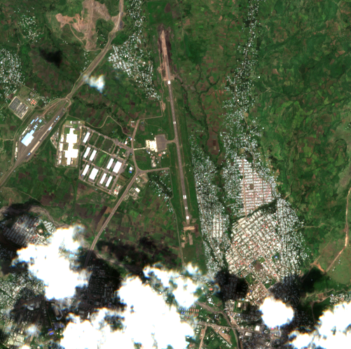
Satellite image before the reported event
24 September, 07:56Z · before
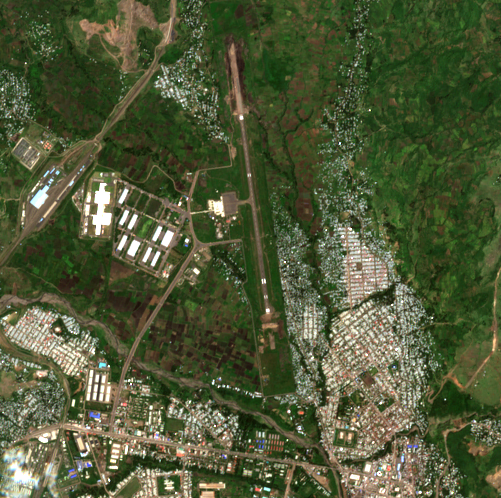
Satellite image after the reported event
29 September, 07:56Z · after

5.1 km across · Sentinel-2 (S2B) MSI L2A · 10.0 m per pixel · identical extent and scale

እዚ ከርእዮ ዝኽእልን ዘይክእልን። Sentinel-2 true colour at 10 m per pixel, acquired 34.9 h after the reported event time. One pixel is roughly the footprint of a small building, so damage to an individual structure, a crater, or munition debris would not be resolved. This imagery could show a burn scar, a large destroyed or removed structure, a plume caught at the moment of overpass, or substantial change to fuel or vehicle areas. Absence of visible change therefore carries little information about whether a small strike occurred. For THIS incident the floor matters less than usual: the reported target is a fuel depot, and a burning fuel installation produces a soot and burn scar tens of metres across that persists for weeks. That is well within what 10 m imagery resolves. A null result here therefore carries real weight, unlike a null against a single munition impact.

ትዕዝብትታት

እቲ መርትዖ ዘርእዮ

ንሕና እንርእዮ

ነቶም ናይ 24 Septemberን 29 Septemberን ተመሳሳሊ 5.0 x 5.0 km ስፍሓት ዘለዎም ስእልታት ክነጻጸሩ ከለዉ፡ ከምኡ'ውን ነቲ ኣብ ማእከል ዘሎ 1.8 km ከባቢ እቲ መዓርፎ ነፈርቲ ክምርመር ከሎ፡ እቲ መዕረፊ ነፈርቲ፡ መሕለፊ ነፈርቲ፡ መቆሚ ነፈርቲ፡ ህንጻታት ተርሚናልን እቲ ናብ ምዕራብ ዘሎ ኢንዱስትርያዊ ፓርክን ኩሎም ድሕኑን ዘይተለወጠን ይመስሉ። ዝኾነ ናይ ባርዕ በሰላ፡ ዝኾነ ዝጸለመ መሬት፡ ዝኾነ ናይ ትኪ ምልክት፡ ዝኾነ ዝፈረሰ ወይ ዝተኣልየ ህንጻ ከምኡ'ውን ዝኾነ ዝተዘርገ መሬት ኣይረአን። ኣብ ክልቲኡ ስእሊ ዝኾነ መኽዘን ነዳዲ ክልለ ኣይክእልን እዩ፡ ኣብ OpenStreetMap እውን ዝተሰርዐ የለን። ኣብ መንጎ እዘን ክልተ ዕለታት ዘሎ ፍልልያት ኣብ ሕብሪ ጎልጎልን ሓፈሻዊ ብሩህነትን ዝተሓጽረ እዩ። እቲ ናይ 24 September ትርኢት ኣብ ልዕሊ እቲ ስእሊ 19.7% ደበና ሒዙ ኣሎ፡ ግናኸ እቲ ደበና ኣብ ደቡባዊ-ምዕራብ ኩርናዕ ይርከብ እቲ መዓርፎ ነፈርትን ኢንዱስትርያዊ ፓርክን ድማ ኣብ ክልቲኡ ስእልታት ንጹር እዩ።

ምስ ምንታይ ከም ዝሰማማዕ

ኣብ መንጎ እዘን ክልተ ዕለታት ኣብቲ መዓርፎ ነፈርቲ ወይ ኣብቲ ጥቓኡ ዘሎ ኢንዱስትርያዊ ፓርክ ዝኾነ ዓቢ ሓዊ ወይ ናይ ህንጻ ዕንወት ምስ ዘይምህላዉ ዝሰማማዕ እዩ። እዚ ኣብቲ ቦታ ድሮን ተተኲሱ እንተነይሩ፡ ዝኾነ ኣጽዋር ወቒዑን ክነድድ ዘይከኣለን እንተኾይኑ፡ ወይ ንእሽቶ ሓዊ ኣብ መሬት ምልክት ቅድሚ ምሕዳጉ ተቖጻጺሮምዎ እንተኾይኖም ኣይገልጽን እዩ። እቲ ተጸብጺቡ ዘሎ መኽዘን ነዳዲ ዝርከበሉ ቦታ ባዕሉ ዘይተረጋገጸ እዩ፡ ስለዚ እዚ ትዕዝብቲ ነቲ ዝተረጋገጸ ዒላማ ዘይኮነስ ነቲ ተጸብጺቡ ዘሎ ከባቢ ይሽፍን。

ንሕና እንርእዮ

ብ 28 September ወይ ካብ 25 September ክሳብ 2 October ኣብ ዘሎ ግዜ ኣብ መዓርፎ ነፈርቲ ኮምቦልቻ ወይ ኣብ ጥቓኡ ዝኾነ ናይ FIRMS ናይ ሙቐት ዳህሳስ ኣይተረኽበን፤ እቲ ዝቐረበ ብ 25 September 54.4 km ርሒቑ ዝነበረ እዩ። ብ 28 September ሰዓት 11:25 UTC ዝሓለፈ ናይ VIIRS NOAA-20 ናይ ቀትሪ ዳህሳስ 120 km ርሒቑ 4.12 ን 2.56 MW ናይ ሓዊ ራድየሽን ሓይሊ ዘለዎም ክልተ ባርዕ ሓዊ ኣለልዩ። ኣብቲ 150 km ከባቢ ዝተረኽቡ ኩሎም ትሽዓተ ዳህሳሳት ካብ 1.06 ክሳብ 30.94 MW ዝበጽሑ ኮይኖም፣ እዚ ድማ መጠን ናይ ልሙድ ናይ ሕርሻ ምንዳድ እዩ።

ምስ ምንታይ ከም ዝሰማማዕ

ካብ ናይ ኣዲስ ኩነታት ብዝተፈልየ፣ እዚ ባዶ ውጽኢት ትርጉም ዘለዎ እምበር ሓበሬታ ዘይብሉ ኣይኮነን። ዝነድድ ዘሎ መኽዘን ነዳዲ ቀጻልነት ዘለዎ፣ ልዑል ሓይሊ ዘለዎ ምንጪ ሙቐት እዩ — ካብዚ ኣብዚ ዝረአ ዘሎ 1-31 MW ድሕረ-ባይታ ብዕጽፊ ዝዓቢ — ከምኡ’ውን ሓደ ናይ 375 m ዳህሳሲ ብልክዕ ነዚ ንምልላይ ዝተሰርሐ እዩ። ብናይ 28 September ዳህሳስ እቲ ዳህሳሲ በታ መዓልቲ ነዚ ላቲቱድ ይዕዘብ ከምዝነበረ ተረጋጊጹ እዩ፣ ስለዚ እቲ ዘይምህላው ናይ ሓዊ ዘይምህላው እምበር ናይ ዘይምዕዛብ ኣይኮነን። እቶም ደረታት ሓቀኛታት እኳ እንተኾኑ ካብቲ ልሙድ ግን ዝጸበቡ እዮም፡ እቲ መጥቃዕቲ ዝተፈጸመሉ ዝተባህለ ግዜ ዘይተፈለጠ እዩ፣ እቲ ዳህሳስ ናይ ሓደ እዋን ስእሊ እምበር ቀጻሊ ክትትል ኣይኮነን፣ ከምኡ’ውን ድሕሪ 14:25 EAT ዝጀመረን ቀልጢፉ ዝጠፍአን ሓዊ ኣብ መንጎ እቶም ዳህሳሳት ክወድቕ ይኽእል እዩ። ይኹን እምበር ናይ ዝነደደ በሰላ ክገድፍ ትጽቢት ይግበር፣ ዝረአ ግን የለን።

ገምጋማት

ክሲ ብኽሲ

ብ28 September ሓደ ርእሰ-ቅትለት መጥቃዕቲ ድሮን ኣብ መዓርፎ ነፈርቲ ኮምቦልቻ ዝርከብ መኽዘን ነዳዲ ዒላማ ገይሩ።

Claimed by ACLED (Dr Jalale Getachew Birru, ላዕለዋይ ተንታኒ ምብራቕ ኣፍሪቃ) · source rating B3

ደሓን ተኽእሎ 45–55%

ሓደ ምንጪ ነዚ ይጽብጽብ፣ ካልኣይ ድማ ኣይረኸብናን። ACLED ነቲ መጥቃዕቲ ናብ Alliance for Survival ዘላግቦ ከም ርኽበት ዘይኮነስ ከም እምነት እዩ፣ መጥቃዕቲ ተፈቲኑ እንተኾይኑ ከነረጋግጸሉ እንኽእል መገዲ ድማ የብልናን።

ነዚ ዘሓላልኾ ነገር

No independent check run.

እንታይ ሓሳብና ክቕይሮ ይኽእል

ዝኾነ ጂኦሎኬት ዝተገብረ ምስሊ ወይ ቪድዮ፣ ኣብታ ዝተባህለት ለይቲ ናይ FIRMS ዋዒ ምርካብ፣ ወይ ናይ መዓርፎ ነፈርቲ NOTAM። እቶም ጸብጻባት ናብ ሓደ ናይ ማሕበራዊ-ሚድያ ጽሑፍ ከምዝምለሱ ምርግጋጽ ነዚ ከውርዶ እዩ።

ብ28 September ወይ ኣብ ከባቢኡ ኣብ መዓርፎ ነፈርቲ ኮምቦልቻ ዓቢ ባርዕ ነዳዲ ኣስዒቡ።

Claimed by እቲ ዝተጸብጸበ መጥቃዕቲ ምስቲ እቶም ዳሳስቲ (sensors) ክረኽብዎ ዝኽእሉ ንምምርማር፣ ናትና ኣቀራርባ · source rating F6

ትሑት ተኽእሎ 20–45%

እዚ ዘለና ዝነጸረ መልሲ እዩ። ዝነድድ ዘሎ መኽዘን ነዳዲ ምስልታት ሳተላይትን ሓዊ-ዝምርምሩ ዳሳስትን ክርእይዎ ዝኽእሉ እኹል ዓብን ውዑይን እዩ፣ ከምኡ'ውን በታ መዓልቲ እቲኣ ዝሓለፈ ሳተላይት ነቲ ከባቢ ሸፊንዎ ነይሩ። ክልቲኦም ዝኾነ ነገር ኣይረኣዩን፣ ድሕሪ ሓሙሽተ መዓልታት ድማ ዝኾነ ናይ ባርዕ በሰላ ኣይረአን። እቲ መኽዘን ዘለዎ ትኽክለኛ ቦታ ዘይተረጋገጸ ብምዃኑን ቀልጢፉ ዝጠፍአ ንእሽቶ ሓዊ ካብ ክልቲኡ መርመራታት ከምልጥ ስለዝኽእልን ምሉእ ብምሉእ ተነጺጉ ካብ ምባል ንቑጠብ።

ነዚ ዘሓላልኾ ነገር

This is the first null result in this ledger that carries real weight, and the reason is specific: the claimed effect is matched to what the instruments detect. Sentinel-2 at 10 m cannot resolve a single munition impact, but a burning fuel installation leaves a scar tens of metres across. VIIRS at 375 m cannot see a detonation, but a fuel fire is exactly its design case, and the 28 September pass confirms it was looking. Neither of those statements holds for the Addis incident, where the equivalent nulls mean almost nothing. The null still does not reach the targeting claim, which is assessed separately and unchanged.

እንታይ ሓሳብና ክቕይሮ ይኽእል

ኣብቲ ቦታ ናይ ዘሎ ሓዊ ወይ ዕንወት ናይ መሬት ስእሊ ወይ ቪድዮ። ትሕቲ 10 m ደርቢ ናይ ታንኪ ዕንወት ዘርኢ ትሕቲ-ሜተር ምስሊ። እቲ መኽዘን ነዳዲ ካብዚ ተሸፊኑ ዘሎ ከባቢ መዓርፎ ነፈርቲ ወጻኢ ኣብ ካልእ ቦታ ምዃኑ ምርግጋጽ፣ እዚ ድማ ንኽልቲኡ መርመራታት ዘየድሊ ይገብሮ። እቲ ቀጻሊ ናይ 7-day ፍርያት ዝሰሓቶ ሓላፍታት ዝሽፍን፣ ብመፍትሕ ዝግበር ናይ FIRMS ኣርካይቭ ሕቶ። ናይ Ethiopian Airports Enterprise ወይ ናይ መንግስቲ መግለጺ ብዝኾነ መገዲ።
ምንጭታት

እዚ ዝምርኮሰሉ ኩሉ ነገር

  • መጽናዕቲ — ACLED expert comment, 'Blasts in Addis Ababa signal dangerous new phase in Ethiopia's conflict', attributed to Dr Jalale Getachew Birru, East Africa Senior Analyst. States that 'suicide drone strikes are believed to have been carried out by ዝተዓቀበ ቅዳሕ
  • ቴርማል — NASA FIRMS active-fire detections within 150 km of Kombolcha Airport for 25 September to 2 October 2026, from the open 7-day global VIIRS (375 m, NOAA-20 and S-NPP) and MODIS (1 km) products. Nine detections in total. The nearest to the air ካብ ዝተመዝገበ ሕቶ ዳግማይ ዝተፈጠረ

ዓሚቝ ዳህሳስ

ምንጭታትን ቴክኒካዊ መበቆልን

ACLED

ACLED expert comment, 'Blasts in Addis Ababa signal dangerous new phase in Ethiopia's conflict', attributed to Dr Jalale Getachew Birru, East Africa Senior Analyst. States that 'suicide drone strikes are believed to have been carried out by the Alliance for Survival, targeting a fuel depot in Kmbolcha Airport on 28 September' (ACLED's spelling). 'Believed to have been carried out' is ACLED's own hedge and is preserved here.

Technical provenance
Timestamp basis
unknown
Archived at
2026-10-02 17:44:17.577227+00:00
Archive method
existing wayback snapshot
SHA-256
6693c830a8e4d5285fc89aef0b2d2fb02aaf6e1637280e15a501788a006b922b

Satellite image · 24 Sep 2026

Sentinel-2 true-colour crop of Kombolcha Airport and the adjacent industrial park, acquired 2026-09-24T07:56Z, before the reported strike.

Technical provenance
Captured at
2026-09-24 07:56:49.953000+00:00
Timestamp basis
exif
Archived at
2026-10-02 17:53:08.981413+00:00
Archive method
wayback save page now
SHA-256
8ac1f835b2ee5c5bde3e93aad3de9d6aa5d92641f574c2dce9cce217a5ee514f
Licence
Copernicus Sentinel data 2026, processed by ESA. Free and open under the Copernicus licence; redistribution permitted with attribution.
Artifact type
satellite_rgb
Sensor
Sentinel-2 (S2B) MSI L2A
Acquisition start
2026-09-24T07:56:49.953000Z
Source scene id
S2B_37PEN_20260924_0_L2A
Source url
https://earth-search.aws.element84.com/v1/collections/sentinel-2-l2a/items/S2B_37PEN_20260924_0_L2A
Source catalog
Element 84 Earth Search v1 / AWS Open Data sentinel-cogs
Artifact path
media/artifacts/8ac1f835b2ee5c5b.png
Sha256
8ac1f835b2ee5c5bde3e93aad3de9d6aa5d92641f574c2dce9cce217a5ee514f
Processing
["earth-search STAC query (sentinel-2-l2a)", "windowed read of asset 'visual' at native resolution (EPSG:32637)", "bands 1-3 as RGB", "PNG encode"]
Bbox
[39.702714, 11.084682, 39.748486, 11.129598]
Crs
EPSG:4326
Resolution m
10.0
Cloud cover pct
19.7081
License
Copernicus Sentinel data 2026, processed by ESA. Free and open under the Copernicus licence; redistribution permitted with attribution.
Redistributable
True
Detectability note
Sentinel-2 true colour at 10 m per pixel, acquired 85.1 h before the reported event time. One pixel is roughly the footprint of a small building, so damage to an individual structure, a crater, or munition debris would not be resolved. This imagery could show a burn scar, a large destroyed or removed structure, a plume caught at the moment of overpass, or substantial change to fuel or vehicle areas. Absence of visible change therefore carries little information about whether a small strike occurred. For THIS incident the floor matters less than usual: the reported target is a fuel depot, and a burning fuel installation produces a soot and burn scar tens of metres across that persists for weeks. That is well within what 10 m imagery resolves. A null result here therefore carries real weight, unlike a null against a single munition impact.

Satellite image · 29 Sep 2026

Sentinel-2 true-colour crop of Kombolcha Airport and the adjacent industrial park, acquired 2026-09-29T07:56Z, after the reported strike.

Technical provenance
Captured at
2026-09-29 07:56:53.155000+00:00
Timestamp basis
exif
Archived at
2026-10-02 17:53:23.837248+00:00
Archive method
wayback save page now
SHA-256
7dc5505eba578f90d194fa1fef4823a2178f36c90938a952a59cde01c966b876
Licence
Copernicus Sentinel data 2026, processed by ESA. Free and open under the Copernicus licence; redistribution permitted with attribution.
Artifact type
satellite_rgb
Sensor
Sentinel-2 (S2C) MSI L2A
Acquisition start
2026-09-29T07:56:53.155000Z
Source scene id
S2C_37PEN_20260929_0_L2A
Source url
https://earth-search.aws.element84.com/v1/collections/sentinel-2-l2a/items/S2C_37PEN_20260929_0_L2A
Source catalog
Element 84 Earth Search v1 / AWS Open Data sentinel-cogs
Artifact path
media/artifacts/7dc5505eba578f90.png
Sha256
7dc5505eba578f90d194fa1fef4823a2178f36c90938a952a59cde01c966b876
Processing
["earth-search STAC query (sentinel-2-l2a)", "windowed read of asset 'visual' at native resolution (EPSG:32637)", "bands 1-3 as RGB", "PNG encode"]
Bbox
[39.702714, 11.084682, 39.748486, 11.129598]
Crs
EPSG:4326
Resolution m
10.0
Cloud cover pct
4.4842
License
Copernicus Sentinel data 2026, processed by ESA. Free and open under the Copernicus licence; redistribution permitted with attribution.
Redistributable
True
Detectability note
Sentinel-2 true colour at 10 m per pixel, acquired 34.9 h after the reported event time. One pixel is roughly the footprint of a small building, so damage to an individual structure, a crater, or munition debris would not be resolved. This imagery could show a burn scar, a large destroyed or removed structure, a plume caught at the moment of overpass, or substantial change to fuel or vehicle areas. Absence of visible change therefore carries little information about whether a small strike occurred. For THIS incident the floor matters less than usual: the reported target is a fuel depot, and a burning fuel installation produces a soot and burn scar tens of metres across that persists for weeks. That is well within what 10 m imagery resolves. A null result here therefore carries real weight, unlike a null against a single munition impact.

Fire-detection data

NASA FIRMS active-fire detections within 150 km of Kombolcha Airport for 25 September to 2 October 2026, from the open 7-day global VIIRS (375 m, NOAA-20 and S-NPP) and MODIS (1 km) products. Nine detections in total. The nearest to the airport at any time in the window is 54.4 km away, on 25 September. Nothing at or near the airport on 28 September or after. Critically, the window DOES contain a daytime VIIRS NOAA-20 pass on 28 September at 11:25 UTC (14:25 EAT) which detected two fires 120 km away, establishing that the sensor was operating and the swath covered this latitude on the day in question.

Technical provenance
Timestamp basis
exif
SHA-256
c8de605f74f7303021966738822d19b263ff8e69732ee64d50daf215a1095e50
Reproduction procedure
Stream the open 7-day global CSVs for noaa-20-viirs-c2, suomi-npp-viirs-c2 and modis-c6.1 from firms.modaps.eosdis.nasa.gov/data/active_fire/, filter to Ethiopia (lat 3.0-15.5, lon 32.5-48.5), then to within 150 km of 11.10714, 39.72560. No API key is needed for the 7-day products. Note the window is ROLLING: after 2026-10-02 these files no longer cover 28 September, which is why the filtered subset is stored here rather than only the query.
Upstream sources
["NASA FIRMS / VIIRS and MODIS active fire products"]