Dahsas

በGoogle Translation የተተረጎመ · እንግሊዝኛ

27 መስከረም 2026 · የሰመራ አየር ማረፊያ (SZE/HASM)፣ አፋር

እውነት ነው?ሊሆን የሚችል~70%

በአፋር፣ ሰመራ አውሮፕላን ማረፊያ ላይ የተዘገበ የድሮን ጥቃት

ተሻሽሏል

ይህ መዝገብ ምንም ቀን አልነበረውም እናም ይህንኑ ገልጿል፡ አንዱ ተረጋግጧል እስኪሆን ድረስ ምንም ማረጋገጥ አልተቻለም። የCritical Threats Project የ1 October ሪፖርት ይህንን ያቀርባል። ጥቃቶች በ27 September የሰመራ አየር ማረፊያን እና ኮምቦልቻን ኢላማ እንዳደረጉ ተዘግቧል። CTP ዝቅተኛ ጥራት ካለው ምስል በሰመራ ሊኖር የሚችል ጉዳትን ይገልጻል፣ መረጃውን ለBrady Africk እና ለEuropean Union መረጃ በመስጠት፣ እና በራሱ ግምገማ ጉዳቱን በነጻነት ማረጋገጥ እንዳልቻለ ይናገራል።

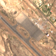
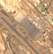
እኛ ተመሳሳይ የSentinel-2 ምስሎችን አውጥተናል እና ከተዘገበው ቀን በኋላ የመጀመሪያው ምልከታ የሆነውን 29 September ጨምረናል። በ24 እና 29 September መካከል በአውሮፕላን ማቆሚያው ላይ ከደማቅ ስብስብ አጠገብ ትንሽ ጥቁር ቅርጽ ይታያል።

ከዚያም በ29 September እና በ1 October መካከል እንደገና በበለጠ ይቀየራል። አንድ ነጠላ ጥቃት ድንገተኛ ለውጥ እና ከዚያም የተረጋጋ ጠባሳ ይፈጥራል። ይህ ያ ቅርጽ አይደለም፣ እና ከአንድ ነገር እና ከጥላው ጋር ይበልጥ ተመሳሳይ ነው። በten metres የትኛው እንደሆነ መናገር አንችልም፣ እና ለመመዝገብ በጣም ትንሽ የሆነ ጉዳት በጭራሽ አይታይም። ምን እንደተመታ፣ በማን፣ ወይም በምን ውጤት በማንም ተረጋግጧል አልተደረገም።

Claim
15204555809599 ← ተሰርዟል ተረጋግጧል →
በ27 September 2026 የድሮን ጥቃት የሰመራ አየር ማረፊያን ኢላማ አድርጓል።ምንጩ ያልተጠቀሰ፣ የ CTP የምስል ትንተናን በመጥቀስ የተላለፈሊሆን የሚችል
ሊሆን የሚችል
የሳተላይት ምስል ከተዘገበው ጥቃት በኋላ በሰመራ አየር ማረፊያ ላይ ጉዳት ያሳያል።Critical Threats Project፣ ዝቅተኛ ጥራት ባለው ምስል ላይ ሊኖር የሚችል ጉዳትን ሲገልጽዝቀተኛ አድል ያለው
ዝቀተኛ አድል ያለው

ሳተላይት

በፊት እና በኋላ

Satellite image before the reported event
24 September, 07:56Z · before
Satellite image after the reported event
29 September, 07:56Z · after

1.1 km across · Sentinel-2 (S2B) MSI L2A · 10.0 m per pixel · identical extent and scale

ይህ ሊያሳየው የሚችለው እና የማይችለው። Sentinel-2 true colour at ten metres per pixel over a 1.1 km box on the Semera airport apron. The window is 110 by 111 native samples. At this scale a parked aircraft is one or two samples and a vehicle is less than one. This imagery could show a destroyed hangar, a large burned area or a cratered runway. It cannot identify an aircraft, a weapon, a casualty or who was responsible, and it cannot separate a new object from its own shadow.

ምልከታዎች

ማስረጃው የሚያሳየው

የምናየው

በአውሮፕላን ማቆሚያው ላይ ባለ 110 በ 111 የናሙና መስኮት ውስጥ፣ በ 24 September ምንም ጥቁር ገጽታ የለም። በ 29 September አንድ ብሩህ ስብስብ አጠገብ፣ በ 11.7925 N, 40.9921 E ዙሪያ ያማከለ አንድ ይታያል። እዚያ ያለው የሶስት በሶስት ናሙናዎች አማካይ ብሩህነት በ 24 September 192.3፣ በ 29 September 180.4 እና በ 1 October 140.4 ነው። 29 September ን ከ 1 October ጋር እንደ መቆጣጠሪያ በመውሰድ፣ ሁለቱም ሪፖርት ከተደረገው ቀን በኋላ፣ በጣም የተቀየረው ነጠላ ናሙና በ 120 ዲጂታል ቁጥሮች ይጨልማል፣ ይህ ክስተቱን ከያዘው የጊዜ ክፍተት ውስጥ ከሚጨልመው 71 ይበልጣል። ከአራት ጠንካራ ሲግማ በላይ የሚቀየረው የመስኮቱ ድርሻ ለክስተቱ የጊዜ ክፍተት 2.36 per cent፣ ከ 24 September እስከ 1 October 2.01 per cent እና ከክስተቱ በኋላ ላለው መቆጣጠሪያ 1.67 per cent ነው።

ከምን ጋር እንደሚጣጣም

አንድ ግጭት ድንገተኛ ለውጥ እና ከዚያም በቦታው የሚቆይ ምልክት ይተዋል። ይህ ገጽታ ግን ሪፖርት ከተደረገው ቀን በኋላ መቀየሩን ይቀጥላል፣ እና ከክስተቱ በኋላ ባሉት ሁለት ምልከታዎች መካከል በብዛት ይቀየራል፣ ይህም ከመዋቅራዊ ጉዳት ይልቅ የሚንቀሳቀስ ነገር ወይም የሚቀያየር ጥላ ንድፍ ነው። ከአንድ ብሩህ ስብስብ አጠገብ ያለው ቦታው ከአንድ ነገር እና ከራሱ ጥላ ጋር ይጣጣማል። ከዚህ ውስጥ አንዳቸውም ምንም ነገር እንዳልተመታ አያረጋግጥም፡ በአስር metres የተጎዳ ህንፃ ወይም ጥቂት አውሮፕላኖች ላይመዘገቡ ይችላሉ።

ግምገማዎች

የይገባኛል ጥያቄ በይገባኛል ጥያቄ

በ27 September 2026 የድሮን ጥቃት የሰመራ አየር ማረፊያን ኢላማ አድርጓል።

Claimed by ምንጩ ያልተጠቀሰ፣ የ CTP የምስል ትንተናን በመጥቀስ የተላለፈ · source rating F6

ሊሆን የሚችል 55–80%

የCritical Threats Project የተዘገበውን ጥቃት ቀን ወደ 27 September ያደርገዋል እና አየር ማረፊያውን እንደ ኢላማ ይሰይማል።

ጉዳዩን የሚያወሳስበው

አንድ የትንታኔ ምንጭ ከማየት ይልቅ ዘገባን ያጠቃልላል። CTP ጉዳትን ማረጋገጥ እንዳልቻለ ይናገራል። ቀኑ አዲስ ተረጋግጧል ነው እንጂ ከረጅም ጊዜ በፊት የተረጋገጠ አይደለም፣ እና ይኸው ምንጭ የኮምቦልቻን ጥቃት ቀን ወደ 27 September ያደርገዋል የኛ መዝገብ ግን 28th ይላል።

ሐሳባችንን ምን ሊለውጠው ይችላል

ከአየር ማረፊያው አስተዳዳሪ ወይም ከአቪዬሽን ባለስልጣን የሚቃረን ቀን፣ ወይም የሰመራን ጥቃት በሌላ ቀን ላይ የሚያደርግ ዘገባ።

የሳተላይት ምስል ከተዘገበው ጥቃት በኋላ በሰመራ አየር ማረፊያ ላይ ጉዳት ያሳያል።

Claimed by Critical Threats Project፣ ዝቅተኛ ጥራት ባለው ምስል ላይ ሊኖር የሚችል ጉዳትን ሲገልጽ · source rating B3

ዝቀተኛ አድል ያለው 20–45%

ከ 24 September በኋላ በአውሮፕላን ማቆሚያው ላይ የሆነ ነገር ይቀየራል፣ ከዚያም ሪፖርት ከተደረገው ጥቃት በኋላ ባሉት ሁለት ቀናት መካከል እንደገና፣ በበለጠ፣ ይቀየራል።

ጉዳዩን የሚያወሳስበው

ጥቃት ድንገተኛ ለውጥ እና ከዚያም የተረጋጋ ምልክት ይተዋል። ይህ መንቀሳቀሱን ይቀጥላል፣ ይህም ከጉዳት ይልቅ ወደ አንድ ነገር ወይም ጥላ ያመለክታል። በአስር metres per pixel የትኛው እንደሆነ መለየት አንችልም፣ እና ለመታየት በጣም ትንሽ የሆነ ጉዳት አይታይም።

ሐሳባችንን ምን ሊለውጠው ይችላል

የአውሮፕላን ማቆሚያው ከፍተኛ ጥራት ያለው ምስል፣ ቀን የተጻፈበት የመሬት ፎቶግራፍ፣ ወይም በአውሮፕላን ማረፊያው ስላለው ጉዳት ይፋዊ መግለጫ።

ምንጮች

ይህ የተመሰረተበት ሁሉም ነገር

  • ሪፖርት — The Critical Threats Project is reported to have examined satellite imagery relating to reported strikes at locations including Bishoftu and Semera. no source URL recovered
  • ምርምር — Critical Threats Project analysis of 1 October 2026. States that strikes reportedly targeted the Kombolcha airport and the Semera airport in Afar on 27 September, and that low-resolution satellite imagery shows possible damage at Semera air በማህደር የተቀመጠ ቅጂ

ጥልቅ ዳሰሳ

ምንጮች እና ቴክኒካዊ መነሻ

Report · original source not recovered

The Critical Threats Project is reported to have examined satellite imagery relating to reported strikes at locations including Bishoftu and Semera.

Technical provenance
Timestamp basis
unknown

Criticalthreats

Critical Threats Project analysis of 1 October 2026. States that strikes reportedly targeted the Kombolcha airport and the Semera airport in Afar on 27 September, and that low-resolution satellite imagery shows possible damage at Semera airport. Its Figure 3, 'Possible Damage at Semera Airport, October 1, 2026', is credited to Brady Africk and European Union data. CTP states it could not independently corroborate damage in its own review of low-resolution imagery.

Technical provenance
Timestamp basis
unknown
Archived at
2026-10-06 00:26:06+00:00
Archive method
wayback-existing-snapshot
SHA-256
08e648cbdf02b6de21c735b40fd9fdc5398f3da7edffb70d66fbd8ef630cbebe
Upstream sources
["Critical Threats Project"]

Satellite image · 24 Sep 2026

Sentinel-2 true colour over Semera airport apron, 24 September 07:56Z, three days before the reported strike. The same pre-event date used by the Critical Threats Project.

Technical provenance
Captured at
2026-09-24 07:56:30+00:00
Timestamp basis
platform
Licence
Copernicus Sentinel data 2026, processed by ESA. Free and open under the Copernicus licence; redistribution permitted with attribution.
Reproduction procedure
earth-search sentinel-2-l2a S2B_37PGP_20260924_0_L2A, windowed to 40.985,11.787,40.995,11.797
Upstream sources
["Element 84 Earth Search v1 / AWS Open Data sentinel-cogs"]
Artifact type
satellite_rgb
Sensor
Sentinel-2 (S2B) MSI L2A
Acquisition start
2026-09-24T07:56:30Z
Source scene id
S2B_37PGP_20260924_0_L2A
Source url
https://earth-search.aws.element84.com/v1/collections/sentinel-2-l2a/items/S2B_37PGP_20260924_0_L2A
Source catalog
Element 84 Earth Search v1 / AWS Open Data sentinel-cogs
Artifact path
media/artifacts/f848b96b180a6867.png
Sha256
f848b96b180a68671703fec5e40d9b4657fe1fb1cf156809ddc47727791e3a68
Processing
["earth-search STAC query (sentinel-2-l2a)", "windowed read of asset 'visual' at native resolution (EPSG:32637)", "bands 1-3 as RGB", "PNG encode"]
Bbox
[40.985, 11.787, 40.995, 11.797]
Crs
EPSG:4326
Resolution m
10.0
Cloud cover pct
1.05
License
Copernicus Sentinel data 2026, processed by ESA. Free and open under the Copernicus licence; redistribution permitted with attribution.
Redistributable
True
Detectability note
Sentinel-2 true colour at ten metres per pixel over a 1.1 km box on the Semera airport apron. The window is 110 by 111 native samples. At this scale a parked aircraft is one or two samples and a vehicle is less than one. This imagery could show a destroyed hangar, a large burned area or a cratered runway. It cannot identify an aircraft, a weapon, a casualty or who was responsible, and it cannot separate a new object from its own shadow.

Satellite image · 29 Sep 2026

Sentinel-2 true colour over the same box, 29 September 07:56Z, the first observation after the reported 27 September strike.

Technical provenance
Captured at
2026-09-29 07:56:31+00:00
Timestamp basis
platform
Licence
Copernicus Sentinel data 2026, processed by ESA. Free and open under the Copernicus licence; redistribution permitted with attribution.
Reproduction procedure
earth-search sentinel-2-l2a S2C_37PGP_20260929_0_L2A, windowed to 40.985,11.787,40.995,11.797
Upstream sources
["Element 84 Earth Search v1 / AWS Open Data sentinel-cogs"]
Artifact type
satellite_rgb
Sensor
Sentinel-2 (S2C) MSI L2A
Acquisition start
2026-09-29T07:56:31Z
Source scene id
S2C_37PGP_20260929_0_L2A
Source url
https://earth-search.aws.element84.com/v1/collections/sentinel-2-l2a/items/S2C_37PGP_20260929_0_L2A
Source catalog
Element 84 Earth Search v1 / AWS Open Data sentinel-cogs
Artifact path
media/artifacts/0c498ba0fde66865.png
Sha256
0c498ba0fde66865df8d3d0a6dc1df60c55017c48fecd6e8ad4fc8d95fa5cad2
Processing
["earth-search STAC query (sentinel-2-l2a)", "windowed read of asset 'visual' at native resolution (EPSG:32637)", "bands 1-3 as RGB", "PNG encode"]
Bbox
[40.985, 11.787, 40.995, 11.797]
Crs
EPSG:4326
Resolution m
10.0
Cloud cover pct
0.2
License
Copernicus Sentinel data 2026, processed by ESA. Free and open under the Copernicus licence; redistribution permitted with attribution.
Redistributable
True
Detectability note
Sentinel-2 true colour at ten metres per pixel over a 1.1 km box on the Semera airport apron. The window is 110 by 111 native samples. At this scale a parked aircraft is one or two samples and a vehicle is less than one. This imagery could show a destroyed hangar, a large burned area or a cratered runway. It cannot identify an aircraft, a weapon, a casualty or who was responsible, and it cannot separate a new object from its own shadow.